 Unlock with Patreon
About This Episode
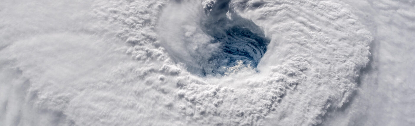
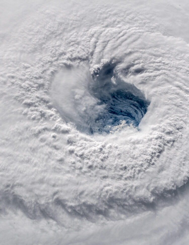
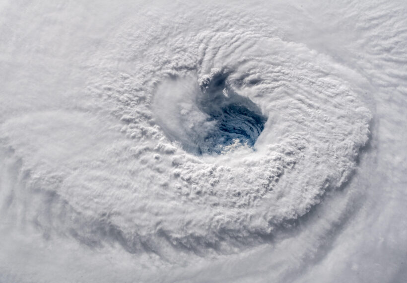
How do we predict our planet’s most powerful forces? Neil deGrasse Tyson and comedian Chuck Nice learn about extreme weather, hurricanes, coronal mass ejections, and preparing for space storms hurtling our way with NOAA Administrator Richard Spinrad.
From the potential of Category 6 hurricanes to the most intense solar storms in decades, we’re exploring how NOAA’s models are helping humanity navigate a rapidly changing climate—and its far-reaching impacts. Learn about the effects of latent heat on hurricane intensity, massive ocean-topography shifts, and how warming waters and wetter storms affect storm severity.
Hear about NOAA’s essential work in tracking extreme weather events like Hurricane Harvey and Helene, and why rapid intensification matters more than ever. And for our future beyond Earth, find out how NOAA is developing models to anticipate intense solar activity, like coronal mass ejections, which can disrupt everything from satellites to electrical grids.
We discuss space weather, climate refugees, and the Argo robot fleets exploring ocean depths for answers. Learn about the Galveston hurricane in 1900 and how technological advancements prevent us from such deadly impacts. Plus, hear about the airplanes and drones that NOAA flies into hurricanes to collect data.
Thanks to our Patrons Dwight N Keown, Nathan Veatch, CURTIS J ESSEN, John Havranek, Vanessa Harding, Aiden Chauvette, Matthew Stork, SpaceTimePete, larry hughes, Anselmo Garcia, Nessa Nova, Tanya Henry, Neil Livingston, oliver stanton, Regis, Micheal Stewart, DP337, Rob Butler, Beth, and Caton Smith for supporting us this week.
NOTE: StarTalk+ Patrons can listen to this entire episode commercial-free.
Transcript
DOWNLOAD SRTChuck, we don’t always get access to the operations of the US government.
And occasionally, we’ll bring in the head of an agency.
And I loved it bringing in the head of NOAA.
Yeah, and I loved it because now we have the inside betting track on the next hurricane.
Is that right?
There’s sporting events in Vegas, there’s like the hurricane track.
We got the line, baby.
Okay, if you want to bet on the next hurricane, tune in to this coming episode of StarTalk.
Welcome to StarTalk, your place in the universe where science and pop culture collide.
StarTalk begins right now.
This is StarTalk.
Neil deGrasse Tyson, your personal astrophysicist.
Got with me Chuck Nice.
Chuckie, baby, how are you doing?
Hey, Neil.
So Chuck, today’s topic is the weather.
Ah, excellent.
Yes.
That’s supposed to be the safest thing to talk about with anyone, right?
No longer.
Oh, no, I guess not.
Very good point.
No longer.
Very good point, but we know that it’s extreme.
And if we comb the earth to find who’s the top weather person, that’s going to be.
Sam Champion.
W-A-B-C News.
He’s amazing.
It’s going to be, every local news has their person who they are certain is like the best weather forecaster there is, but we can go above them all because we’re StarTalk and we have access and we’ve brought in the chief head honcho of NOAA, the National Oceanic and Atmospheric Administration, Dr.
Richard Spinrad.
Oh my gosh.
Rick, how you doing, man?
Hey, I’m doing great, Neil.
Chuck, delighted to be here.
Thanks.
Let me get your full title straight here.
The Undersecretary of Commerce for Oceans and Atmosphere, and that’s a different title from being NOAA Administrator, is that right?
Yeah.
Actually, my full title will probably take the full duration of this show.
But it is the Undersecretary of Commerce for Oceans and Atmosphere, and the Administrator of NOAA, the National Oceanic and Atmospheric Administration.
So it’s really two hats in this job.
We were reminded that commerce, which is a huge branch of the US government, cares about climate and weather, and goods and services are delivered through the air on the waters over the land.
And our relationship with climate is deeply impacted.
Yeah, like commerce and the melting ice that is causing passage through near Alaska.
And it’s a contest of waters now, because you have Russia, who wants that water, and we, of course, and China, and it’s all because it was ice.
And nobody’s looking at the point that it was ice.
What was once ice is now open water.
It’s now open water, right?
Yeah, yeah.
So tell me a couple of things here.
What is your relationship with the Navy?
Because obviously they care about oceans as well.
Yeah, so that’s a great question, because I actually worked for the Navy for the first part of my professional career.
Is there any part of the government you don’t work for, Richard?
Yeah, Congress.
I have not worked for Congress yet, and that probably won’t happen either.
But Navy, I mean, obviously Navy cares about oceans and climate and atmosphere.
And it’s not just how they operate their ships.
They’re going to be concerned about what the impacts of climate are going to be for their bases.
Think about Norfolk, where we’ve got the Atlantic fleet and sea level rise impacting the operations at the base there.
It’s an important element of naval operations.
This is Norfolk, Virginia, yeah.
Norfolk, Virginia, yeah.
But I could say the same thing about just about anywhere the Navy operates.
They do care about the shoreside facilities.
But they also care about the ability to fly and carry out their missions.
And obviously, I mean, one of the strongest components for Navy is understanding how the ocean changes.
What are the dynamics of the ocean?
How does that affect ships and submarines?
Right.
And also, last I checked, there’s several whole countries in the South Pacific, where the average sea level is just only a few feet.
The land elevation of the land is only a few feet above sea level.
So if we start melting out glaciers, we’ll lose entire countries creating, what do they call it, climate refugees.
Exactly, exactly.
And this is not some sort of theoretical thing that will happen a thousand years from now.
The sea level rise rate that you’re alluding to has increased dramatically.
When I was a grad student, a few decades back, we would talk about sea level rise as being, say, one to three millimeters per year.
In some places, it’s doubled or tripled.
And so consequently, some of these nations are actually gonna be eliminated before the end of this century.
They’ll actually be underwater.
Right.
Yeah.
Whole island nations that will disappear.
Whole island nations.
And tell me, of course, everyone cares about the weather, although climate change has been politicized, as we all know, recently.
I’d like to remind people that NOAA was founded in the year 1970, and it was signed into law by a Republican president.
So the politicization of climate to me feels like a very recent phenomenon, because clearly we all care about the weather, and nobody wants to have the weather get the best of them in any part of their life or job.
Yeah, I think that a lot of the making it a political issue comes from trying to figure out who’s fault this is.
Who do we get to blame for this?
The thing about NOAA is that our mission is very much looking to the future.
We’re about predictions and projections.
For us, it’s less about, hey, who caused this problem?
And more about how well can we predict what the change is going to be in the future?
We talk about seal overrides.
That’s what people hold you to because they try to make decisions based on your predictions.
However, you have a moving goal post at all times, Rick, because quite frankly, what happens is these projections are modeled on what we have now.
But the variable is, do we increase the amount of fossil fuel that we’re burning?
Because I mean, that’s really the issue.
So as you have fossil fuel burning coming online, that changes everything that you guys said was going to happen.
For instance, the predictions that were made previous to now, basically everybody’s like, oh yeah, well, they’re all wrong.
But first they were saying, they’re going to be wrong because it’s not going to happen.
Now they’re saying wrong because it’s happening much quicker.
Yeah.
The models would normally have a future expectation for a rate of CO2 increase or a rate of anything.
Isn’t that right, Rick?
Yeah, that’s right.
And this is what climate scientists would call the assumption of stationarity.
That is to say that things now are what they’re going to be in the future.
And it’s not.
And that’s the whole point is, so how do you take the models that you were talking about, Neil, and initialize them, put the data in up front to start the model?
What assumptions do you make about how those conditions are going to change in a year, in 10 years, in 20 years?
That’s the challenge we have in front of us.
But we’re getting really good at improving the skill on those models.
Now, Ray, has your scope been, I’m wondering, I think when NOAA was founded, by the way, I did a deep dive into this, hardly anyone, certainly not even geologists or biologists, had ever combined ocean and air in the same sort of conversation.
There were atmospheric scientists, there were oceanic scientists, and the full system, the full organic system of all these interplaying parts, it seemed to me only came of age a little later when computer models started having something to say about it.
And so now what I pose to you is, now what’s under NOAA purview is also space weather, like what the sun is doing.
So these look like land grabs to me.
We’re spacecraft.
You started out with just the ocean in there, now you want like the solar system.
The universe, we’re known for the universe.
Yeah, Neil, you’re exactly right.
And it is an Earth system.
And the best place to see that is in how hurricanes form and grow and move.
You can’t predict that without a good understanding of the ocean and the atmosphere.
And, you know, the best example on that one was Hurricane Katrina, which, as you may remember, intensified really quickly before it made landfall around New Orleans.
And we now, looking back, know we could have predicted that better if we’d had better data from the ocean in the Gulf of Mexico.
In other words, if it happened today, you would have predicted it better than we were able to do back in 2005.
Yeah, certainly the what we call the rapid intensification of the hurricane as it made landfall.
And that’s because we would look at the whole ocean, not just the surface of the ocean, to put the data.
Yeah, but you guys, I mean, you’re not, you’re being humble because you’re not tooting your own horn about this last huge storm that we just experienced, where the rapid intensification was predicted and did happen indeed, due primarily to the amount of moisture that was being held in the landmass where the storm was going to traverse.
So, you know, you should, you should say, yeah, we didn’t do it back in 2005, but take this bitches, we did it now.
I’m sorry.
I don’t think, I don’t think he speaks that way, Chuck.
I don’t know.
I love the way you said that, though, Chuck, because you got it right.
So, Rick, catch us up on this thing with land water and how that is not neutral as a forcing, as a forcing factor on a hurricane that makes landfall.
What I understood, there was a recent hurricane that saturated the landscape, the land.
And so now when a hurricane makes landfall, there is sort of latent heat available to it from the water that is in the saturated ground.
Because normally a hurricane would weaken as it goes over the land, right?
Yeah, it’s all about temperatures, right?
And so we know the temperatures of the ocean, in this case Gulf of Mexico, are going up.
We know the temperatures and the atmosphere are going up, which means that those storms can hold more water.
And so think about it, we had Hurricane Harvey that hit Houston, and it dropped five feet, five feet of rain.
When I was a kid, we didn’t talk about feet of rain.
So now you look at what Hurricane Helene just a few weeks ago did, especially in western North Carolina, and the damage was water.
You’re absolutely right.
Most people think hurricane is all about winds.
In that case, it was water.
But in terms of the forcing function on the hurricane itself, that water that’s still had rendered land masses soaked, are you saying that does not continue to play into the…
other than the water has got nowhere else to go, I guess?
Well, that’s basically it.
I think it’s a combination.
If you’ve got soaked terrain from previous precipitation prior to the hurricane coming in, and that hurricane’s got more moisture than it would have before.
Haleem was also huge.
It was a massive hurricane.
It was 500 miles across.
And that’s significantly larger than most hurricanes.
So large hurricane, warm waters, so more moisture available.
The ground was already pretty wet.
And now you’re just dumping buckets onto a wet sponge.
So it’s going to cause a lot of flooding.
Why do I have in my notes that you also care about the bottom of the ocean?
Like, what does that do for you?
Well, there’s a hole in the bottom of the ocean.
No, there’s a plug.
Oh, that’s right.
Yeah.
The bottom of the ocean is important because without a bottom of the ocean, we wouldn’t have an ocean.
Oh, okay.
I mean, so the topography of the ocean is going to drive, help drive how the currents, especially in coastal environments, where the water goes, how it flows, it’s going to impact things like accentuated tides in areas where you’ve got extreme changes, in topography.
So why is this important, especially in the context of a hurricane?
Probably one of the biggest problems, one of the most devastating aspects of hurricanes is storm surge.
What happens to the water, the ocean water when it gets close to the shore, if the topography is just right, you can actually funnel that storm surge and you can end up with 12 to 15 feet.
That’s what they got in Tampa Bay when Hurricane Milton hit.
Yeah.
Hurricane Sandy hit New York.
I mean, I think it was Tropical Storm Sandy at the point it hit New York, but that storm surge is what took us out.
We actually call it Superstorm Sandy because it was both a tropical cyclone and then there was a nor’easter component to it as well.
So it was kind of like the worst of all factors combined.
And yeah, you’re right.
Storm surge.
Yeah, I grew up in New York and my mom was living in an apartment that got flooded as a result of Superstorm Sandy.
And we did not.
That’s interesting.
That was, what, 12 years ago.
We didn’t have the forecast down pat yet.
So, when did you start reaching out and caring about what the sun does?
Well, we’ve always had that as part of our mission.
I think it’s fair to say that-
Obviously, the sun has a luminosity and an energy, but at the next level, the sun cycles and there are solar storms.
And so, it’s not just that there’s a star there delivering energy to your model, there are these fluctuations in the energy to the model that now you guys seem to care about.
Yeah.
So, the sun is a pretty dynamic object, and it goes through these cycles, right?
And we’re actually in the middle of one of these 11-year cycles.
It started last year.
And one of the really interesting aspects of that is that the sun can occasionally actually send out these huge, huge coronal mass ejections, which are these charged gases, the plasmas that get ejected from the surface of the sun at a speed of about one to two million miles per hour.
They are, on the sort of positive side, the factors that create the beautiful northern lights, the aurora borealis.
But a little bit more insidiously, they also interact with navigation systems, they interact with electrical grids, they can affect power grids, they can affect communication systems.
And so, in fact, the storm that erupted in last May, May of 2024.
Solar storm.
The solar storm was a category, what we called G5, geomagnetic storm five, highest ranked storm, one of the most severe that we’ve seen in decades.
But you didn’t hear about it much.
Well, I know you did, Neil, but a lot of people didn’t hear about it.
And that’s because we knew it was coming.
And in years past, we might not have known it was coming.
And so we could make change.
What kind of changes?
Airplanes could change their roots in order to avoid the impact of the solar storm on their GPS systems.
Can you see the actual discharge as it makes its way here?
That is so cool.
Yes, you can.
And in fact, we have just launched.
In June of 2024, we launched a new satellite.
It’s a weather satellite.
It’s the one that you would use when you turn on TV and they show you the full disc of what the weather patterns are on the East Coast or the West Coast.
But this one has a compact coronagraph, and that is the tool that we are using.
I’m sorry.
You guys lost me.
Neil said, oh, nice.
You said compact coronagraph like, you know, like I say, my glasses case.
It’s just like my glasses case.
And I’m like, okay, what is a compact coronagraph?
I got this.
So one of the great inventions of the recent century has been the ability to create an image of the sun in a telescope as though it was a set of optics, as though the sun had just been eclipsed by the moon.
Oh, and when the sun gets eclipsed by the moon, all the bright stuff is blotted out and you see the edge.
You see explosions on the edge.
You remember when we saw the eclipse, this recent eclipse, when we were stationed up in Vermont, you saw these, along the edge, there were these little sort of prominences sticking out.
So imagine being able to do that at will, right?
Rather than waiting around for an eclipse.
Interesting.
And so now, Rick, you say you put one of these in orbit.
That’s cool.
Yeah, we actually have that one in orbit.
There is another sensor on the Discover satellite, which is at the L1, the Lagrange one point.
A big thing, the sun Lagrange?
Yes, exactly.
Now, Chuck, don’t we have a Lagrange explainer?
We do.
For those of you who want to really go a deep dive on Lagrange points, we go all through all L1, 2, 3, 4, and it’s really incredible.
And five.
Can’t leave out all five.
And five.
Clearly, I was only a pay attention for four.
Five is important because we’re in a blue sky.
Five is a really good one.
Five here in a few years.
All Lagrange points are not made equal, right?
But if you want to see how you can find perfect equilibrium in the solar system, to me, that’s what the Lagrange point represents.
Exactly.
Exactly.
So it depends on which two bodies are around which you’re describing the Lagrange points.
So Rick, this is the Earth-Sun Lagrange points, is that correct?
Yeah.
And as you can well describe by having multiple views of the sun from different angles, that is to say, in Earth orbit and then at L1 and at L5, we can look at basically the whole three-dimensional character of the sun because not all of these coronal mass ejections are necessarily aimed at us.
So we need, we care about them all, but at NOAA, we care mostly about the ones that are going to be aimed at us.
And again, to do the math, these things travel in about one to two million miles per hour, sun’s 93 million miles away.
So it’s a three to four day transit that we can get people enough lead time to make preparations for a major geomagnetic storm.
So we can imagine a future where we have a colony on the moon or Mars, where neither of those objects have shielding from this kind of radiation in the way we pretty much do here on Earth with our atmosphere and our ozone layer.
But they don’t.
So presumably they would be deeply connected into your capacity to predict the storm.
Because then everyone would know to run underground or run behind shelters, this sort of thing.
So can I ask, okay, this might be a silly question, but I’m just asking.
So with all your equipment, because NOAA is really a space organization, I mean, you’re looking back at Earth, but all your stuff’s up in the space.
No, no, they got buoys and stuff.
That’s true.
That’s true.
We got to take it back.
I take it back.
Okay.
You’re absolutely right.
But when you talk about these ejections, do you move that stuff or is that stuff just hardened?
I mean, radiations has got to be the most damaging thing for equipment, right?
Yeah.
You’re not going to be able to move this.
I mean, this is immense amounts of energy.
But what you can do is it actually is really similar to our discussion on hurricanes.
We’re not going to be able to move hurricanes in spite of what some people may think.
But we can make the predictions work and we can tell people, this one’s bearing down here on Tampa, plus or minus 20 miles and you got two days to evacuate.
Same thing with space weather.
If we get the picture, especially if you’ve got multiple views, we can say this is going to hit pretty hard in the northern part of Quebec or in Asia and therefore folks can make adjustments.
They have three days, they can power down their grids, their electrical grids, they can re-vector aircraft, so they’re not going to be affected for navigation purposes.
Chuck asked about the satellites that are already in orbit.
They certainly have a susceptibility to this.
You can’t just say, hey, bank a left or hover over Africa until it’s clear over Asia.
You can’t do that.
You can’t.
We can shield some of these to a certain extent, but what we can do is, again, if we know it’s coming, we can make accommodations with regard to power or use another satellite to cover for the one that might be most vulnerable.
The sacrifice satellite.
Yeah, no, we don’t do that.
We don’t put them up for sacrifice.
So there’s something called unexpected events.
Now, I foresee the day where no event is unexpected.
And so no one is taken by surprise.
Where are we now with regard to NOAA’s modeling and other agencies modeling and things just happening, taking everyone by surprise.
There’s a really interesting aspect to your question, Neil, because there’s a famous story in meteorology.
It’s called Isaac Storm.
In fact, Eric Larson wrote a great book on Isaac Storm.
And it was a hurricane that hit Galveston in the year 1900.
For the folks in Galveston in 1900, that storm was an unexpected storm.
They didn’t expect it to hit.
Now, obviously, there’s never going to be another Isaac Storm.
We’ve improved that.
There are things, though, that happen on much shorter time scales.
And so I would say they may not be unexpected, like tornadoes.
But the time that we’re able to give people to react to them and the tornado is shorter.
So right now, for tornadoes, we’re looking at an average lead time on most tornadoes of about 12 minutes.
About 50 years ago, the lead time on tornadoes was minus five minutes.
Okay, that doesn’t even make any sense.
I’m just saying, when the tornado is over, I already know there was a tornado.
That’s right.
That’s right.
Yeah, there is something wrong with that picture.
Just to clarify, you’re not talking about the prediction of the existence of a tornado.
You’re talking about the path a tornado will take once it forms?
Yeah.
The path it’s going to take and how intense it’s going to be.
Got you.
Yeah.
Because there are, like with hurricanes, tornadoes have classifications by intensity.
We have the extended Fujita scale for tornadoes one through five.
It’s the same kind of thing.
So right now, we can say, we think this tornado or this aggregation of tornadoes is going to take this path, and it’s probably going to be an EF2, and it’s probably going to hit over here in 15 minutes.
By the way, 12 minutes, 15 minutes is enough time to get out of the way of a tornado.
Or to go underground.
Yeah, underground.
Yeah.
So that’s incredible.
How do you feel?
I mean, do we have deep resonant emotions when, for example, you go to see a movie that, you know, Storm Chasers movie, you know?
Yeah.
Twisters.
Twisters, how do you, let’s commiserate together here now.
How do you feel when you see these films?
How much effort, do they call you and say, help us get this right?
Or they just make stuff up?
And is it true that in a tornado, I can actually call a cow as it comes by and it goes, and then disappears?
Of course, Chuck, that’s a stupid question.
Everybody knows that.
We are not using bovine sensors in tornadoes for our forecast systems yet.
The cow could just totally hook you up on that.
What is your, if you mind if I ask, what is NOAA’s annual budget?
It’s just under $7 billion.
Would you say that NOAA’s effort saves people and lives on a level far beyond the value of that budget?
Well, I mean, we talk about lives.
The answer is yes, Rick.
You’re the head of the organization.
For Christ’s sake, man.
The answer is yes, right.
Thank you, Rick.
We talk about lives and livelihoods and lifestyles.
So property and lives, but certainly lives.
And the only reason why I hedge is because I can give you the best forecast in the world.
I can give you plenty of lead time, but it’s your decision to evacuate.
It’s your decision to take action.
And we can’t control that.
So we like to think that two things.
One, the quality of our forecast is getting better.
And the second is the trust by the public in that forecast.
And the on-screen meteorologists and emergency managers is high enough so that when we say, you better evacuate, the storm is coming your way, people actually take that action.
But there’s no question.
I mean, I talked to you about the Isaac Storm in Galveston in the year 1900.
And I think the number was something like 10,000 lives were lost in that storm.
That’s not ever gonna happen again in this country, ever.
And that’s because of the quality of the forecast and our ability to have the trust of people to make these decisions.
So yeah, absolutely, we’re saving lives.
And you also affect forecasts for fisheries, right?
And other sort of coastal management of marine food.
Is that a fair…
Yeah, so we do marine forecasts as part of what the Weather Service does.
And we also have responsibility for managing marine fisheries, which means we’re the ones who do the stock assessments of how many fish are out there, how healthy are the fish, how healthy are the populations, and establish regulations for how to sustainably fish for these fish and maintain a strong seafood economy.
Again, we’re part of the Department of Commerce, so it’s an important economic consideration.
So with respect to what you just said, what’s your relationship with other countries?
I know we’re a national organization, but do you have international affiliations like for the typhoon that’s raging in Taiwan right now, or when it comes to sustainability of food supply, like working with China, who just doesn’t give a damn.
So, but what’s your role there?
We care about our coastline and our oceanic property line, if you will, but if you’re studying the entire earth with regard to climate, do you share your data with other countries?
And are they responsive?
And what’s your relationship?
Yeah.
Yeah, we absolutely can’t do our job without strong international collaboration.
And that takes a couple of different forms.
There are worldwide organizations, so it’s a world meteorological organization of which we are a member.
And in fact, the head of our national weather service is the US representative to the WMO.
And it’s these organizations that establish policies with regard to data.
And yeah, all of our NOAA data is publicly available.
And we use that as, if you will, a lever to say to other nations, hey, we’re giving you ours, why don’t you give us yours as well?
So there’s a lot of collaboration for data.
And they recognize they need our data to improve their forecasts.
We need their data to improve our forecasts.
And when you start talking about fisheries, yeah, there’s a lot of international agreements because a lot of the fish are in open ocean waters, and they’re half of the agreements.
And the agreements are not just about, hey, how much fish can we take sustainably?
That is to say, to allow the population of the fish to stay healthy, but also to try to be the protectors of those fisheries by enforcing laws against illegal, unreported and unregulated fisheries, what we call IUU fishing.
So, that requires a lot of international cooperation, because you know what?
It’s a big, big ocean.
You know, it’s not the same thing, but it’s similar in some ways.
The Artemis Accord, which has recently been signed by upwards of 30 countries or so, is a new agreement about conduct in space and space exploration signed by spacefaring nations.
It’s an active accord that’s going on right now.
And so, for example, if you send a rover to the moon or Mars and you learn something about it, you would share that with other countries so that they send a rover, they don’t have to make the same mistakes you did or that you can collaborate.
So it’s interesting how the internationality of what you do certainly would contain tap roots for doing things cooperatively in space.
There’s, yeah, and I think there’s a lot of commonality there.
And I thought that was going through my mind as you were talking about the Artemis Accords, Neil, is that we need to have similar kind of agreements for making observations in the ocean.
There’s no one nation that can cover all of the ocean.
And so we have a major program.
It’s called ARGO.
And it’s basically these robots that go throughout the ocean and they go up and down and all over.
And they drift around.
And we, by international agreement, have said, let’s all agree to what these robots, these floats should look like.
Let’s all build them to these specs.
Let’s put all of these things out there.
So there’s about four or five thousand of these out there now.
And they’ve been floating around for decades.
And let’s all share the data in a common data repository.
These are those buoys that I was thinking about.
Is that right?
These actually dive down.
So they don’t spend a lot of time at the surface.
They float around, and then they ascend to about 1,000 or 2,000 meters depth.
They collect temperature, salinity, other kind of variables that are measured.
They’ll drift for about 10 days out of 2,000 meters, then come back to the surface, transmit their data through satellite communications to a central repository, and then dive back down again and start rinse and repeat, basically.
You know, that’s badass, I just have to say.
It is.
Now you know there are some nations though, they probably got a backdoor, like, if you find oil, don’t tell anybody else.
Let’s take up the subject of climate change for the moment.
So we know, is the fraction a third?
So for every X amount of CO2 that goes into the atmosphere, does the ocean uptake about a third of that, or some fraction of it?
Yeah, there’s a variety of estimates, but that’s pretty close, maybe even closer to a half, but definitely a large percentage.
Okay, so that means the dissolved CO2 in the ocean is in some form of partial pressure equilibrium with the CO2 in the air.
So if we were to stop CO2 production, or even introduce CO2 scrubbers in the atmosphere, we will do this, but then there’s less CO2 pressing down on the ocean, and the ocean says, I have to make equilibrium out of this, and it’ll start releasing.
And it gives it up to the atmosphere.
Gives it up to the atmosphere.
So, is it true that we would not see the immediate effects for quite some time, perhaps decades, even if we stopped all fossil fuel burning today?
The short answer to your question, Neil, is yes.
People talk about the flywheel in the carbon cycle.
You could stop the introduction.
Interesting, you raised the question of actually actively removing carbon dioxide from the atmosphere, which would accelerate the diminishment of excess carbon dioxide in the atmosphere.
But it would still be, yeah, you’re right, decades before we would see the ocean responding in kind.
Part of the problem with the dynamic you described is that the increased carbon dioxide dissolution in the ocean manifests as ocean acidification.
Right.
The pH of the ocean.
The whole other thing going on.
Okay.
Yeah.
Of course.
Yeah.
In that case, it’s not simply a matter of, it’s not like opening up a bottle of Coca-Cola and having all the CO2 go back out of the liquid into the atmosphere.
A lot of this CO2 has become part of the carbon cycle within the atmosphere, including with a decrease in pH and increased acidification.
And that’s where you see the complete bleaching of coral reefs and the death of these coral reefs, which by the way are their entire ecosystems in themselves.
Yeah, yeah.
As part of it, in fact, a major contribution of coral bleaching is actually the temperature.
Temperature, yes.
It’s the warming of the water.
But because of the chemical makeup of most corals, the increased acidification is very corrosive than to the corals.
So when people talk about terraforming Mars and moving there.
I’m sorry, that was just an excellent segue.
My rebuttal to that, it’s not a rebuttal.
My comment on it is, if we have the power of geoengineering to turn Mars into Earth, then we have the power of geoengineering to turn Earth back into Earth.
You wouldn’t need Mars to do that.
And so that’s kind of how I view that.
So Rick, this past hurricane season, is it just my imagination, or were there more Category 5s kicking in than usual?
And if so, is that the new normal?
And what is the new normal?
Right now, today, we’re recording this in October.
It’s like 75 degrees outside.
When it says unseasonably warm temperatures today, will that soon become seasonably warm?
Does unseasonable become seasonable because that’s the new normal?
And will we need a Category 6?
Because these Category 5s keep getting bigger and bigger, and it keeps saying Category 5, but it’s the storm we’ve never seen before.
When are we getting to Category 6?
Chuck, stop poking the bear.
That’s what you’re doing.
I love that question, Chuck, and I will get to it in a minute.
But what I do want to say is, I keep thinking about the New York Times columnist, Tom Friedman, who said it’s not global warming, it’s global weirding.
Weirding.
And if you think about it, Neil, we don’t talk global warming anymore, we talk climate change.
And that’s because it manifests in so many, many different ways.
And fundamentally, fundamentally, what we’re doing is we’re putting more energy into the system because of the greenhouse effect, there’s more energy coming into the system.
So your question about what’s going to be seasonable or not seasonable, what do the storms look like, things are going to be different.
This year, for example, we predicted an above normal hurricane season, and it’s turning out it is above normal by certain measures.
Is that going to become the new normal?
Well, I think just logic suggests that we can probably see a lot more hurricane activity in the future in terms of the intensity of the storms, how much water they have with them, that sort of thing, which gets to Chuck’s comment.
And that is, you know, my take is it’s not about, do we need another category, a Category 6 in the Saffir-Simpson scale?
Chuck wants you to name it after him.
A Chuck hurricane is a Category 6 hurricane.
Well, there’s something wrong with calling something a nice hurricane.
That’s the problem.
We’ll call it not so nice.
Well, you leave out his last name.
We’ll just call it the Chuck hurricane.
The Chuck hurricane.
What we really need in that regard is to expand the focus because the Saffir-Simpson scale is really a measure of wind, right?
How strong are the winds?
You see that every time.
Hey, the winds have just gotten to 130 miles an hour.
So now it’s a cat for that kind of thing.
But when you look at what these hurricanes are doing, we’re looking at impacts of storm surge.
I talked about the volumes of water from hurricanes like Harvey years ago.
We need people to understand that we should be looking at more than just what the peak wind is.
Because you could have a cat 5 with really strong 170 mile an hour winds, but it may not have the impact that a cat 3 has with a large volume of water like Hurricane Helene had.
So we need to find a way for people to understand the full measure of what the hurricanes are, what they look like and what their impact is going to be.
Let me toot your horn for a moment here.
In the 1989 sequel to Back to the Future, titled Back to the Future Part 2, they went into the future, the year 2015.
We’re watching this movie in 1989, and they are imagining the year 2015.
There’s a point where Marty and Doc get out of the car, and Doc puts up an umbrella, and Marty says, what are you doing?
He says, oh, this is the future.
Weather forecasting is now, we know the exact minute it’s going to start to rain.
And right in that instant, it starts to rain, and then it stops, ready, stops, and then it stops, and he puts the umbrella away.
We’re not exactly there, but of course, on our smartphones, it’ll show you when the rain is going to begin, where you are and where it’s going to end.
That’s what I’m saying.
That’s true.
I never even thought of that, but it gives you the time of day.
It’s like 3 p.m.
starts, yeah.
And your spot, and it tells you how much and how intense.
And Chuck, when we were growing up, it was like all you really want to know, what might it rain tomorrow because you have a baby, and then they give you a 50% chance, which means they know absolutely nothing.
Right.
Your grandmother knew more.
My biceidus is acting up.
My shoulder.
I tell you, baby, it’s going to rain tomorrow.
My shoulder.
For all you know, NOAA’s got grandmas in the back room.
Ethel, how’s your knee?
I’ll tell you, I’ll tell you, it’s going to rain.
Ethel predicts the hurricanes.
Well, you know, it’s interesting because I was going to say, Neil, that, yeah, I do have a couple of apps on my phone, in fact, and I use it for just that.
Okay, you know, should we have that picnic now or should we wait an hour?
That kind of thing.
And that’s less about the prediction and more about the observations.
And so the radars that we’ve got, the satellites have got so much resolution right now that you can start doing that.
You can within an hour or two, you can say, hey, this storm, I mean, I use it all the time when I’m walking my dog, I’m saying, all right, should I do it now or should I wait an hour?
So you’re saying that’s because we have real-time observation of what’s happening.
Exactly.
Yeah.
And we can, and tornadoes are a really good example.
You know, we’ve gotten really good at observing tornadoes using some of the new sophisticated applications.
We use something called dual polarization on our weather radars, which is, in the old radars, it was basically just send out a signal and see what comes back.
And now we can start manipulating the signal, looking at the polarization of the signal to determine, is that rain?
Is it sleet?
Is it snow?
And get such good resolution that we can say, yeah, it’s sleet, but we know the temperature two miles away is warmer, and we can see how fast it’s coming.
So in an hour, it’s going to be rain over here.
Wow.
Yeah, that’s okay.
So cool, man.
We actually fly through the hurricanes, and we’ve been doing that for quite a while.
We have two, actually more than that.
We have at least three airplanes that we use to fly through or over the hurricanes.
That’s the right stuff right there.
Want to talk about how to do the right stuff?
And I’ve done that once.
I did it once with our team.
Who you got to pissed off to get that job?
I ran some of the math on this.
If you’re standing there on stationary earth and 170 mile an hour wind is coming by you, that’s going to tumble buses and trucks and the cow, of course, will fly by.
However, an airplane in open air flies 500, 600 miles an hour way faster than the air in a hurricane.
So, is it not as dangerous for an airplane as you might otherwise think?
Yeah, I’m going to be the first to tell you.
It is a dangerous thing to do, but our crews are real aces.
They are amazing professionals.
And the equipment that we fly, we actually fly 50 year old airplanes, but we’re scheduled to buy some brand new ones here soon.
And we fly Navy P3s, the same airplanes that the Navy used to find submarines.
And here’s the kicker, that we fly them high enough through the hurricane, that yeah, when you go through the eye wall of the hurricane, where there’s extraordinary vertical wind currents, you’re going to go through several thousand feet of elevation change.
If you did that on a commercial flight to Cleveland, you’d have a real problem and you’d be sending a complaint to the airline.
Going to be a lot of vouchers given out at the end of that flight.
And we do it repeatedly.
We’ll fly, we’ll do like a figure four pattern through the hurricane two or three times.
And then the other really cool thing though is we don’t just fly those aircraft through the hurricanes at say eight, ten thousand feet.
We also drop drones from the airplanes so that they, those drones can then fly at the lower altitudes and get all the data we need.
So, you know, when you talked about being-
You’re not just joy riding, you’re getting data at every turn.
Oh, we’re getting data after a while.
So real time, it’s going back to the National Hurricane Center.
They are assimilating those data into the predictive models.
And because of those flights, the track and intensity forecasts have improved by 10, 15, 20 percent.
So that real time message to the guy on the beach who says, I don’t know if I should evacuate or not, has gotten so much better.
Look at the look at the tracks from Hurricane Milton.
You saw that.
Two, three days out, we were saying it’s going to hit Tampa, St.
Pete.
Yeah, they were tight.
They were totally tight.
So, Rick, as weather phenomena around the world, even if it’s just simply higher temperatures than ever before, whatever is the phenomenon that’s stretching the limits of what might have been models that were comfortably contained within certain parameters, every time there’s an unprecedented event, that you didn’t predict.
What do you have to do with your models?
What’s the next step here?
Yeah, that’s a great question, especially if you extend it and say, how does something like AI or machine learning, artificial intelligence and machine learning fit in here, and these extraordinary events?
I think some of the heatwaves we’ve seen, some of the droughts we’ve seen are examples.
They end up providing an incredible volume of new data, and our artificial intelligence applications depend critically on what we call training data.
The data from what has happened in the past being used as training for the models of the future.
I would argue when we don’t fully characterize a particular event with our forecasts, but we are able to collect all the data from that event, we are by definition improving our ability to use AI techniques, machine learning techniques.
Except by definition, your AI that’s mining the data, will not have data that is never seen, that is yet to see.
Which is the argument for making sure we fully measure and characterize these extreme events.
And so a lot of our investment at NOAA is building the systems that provide much more intense, higher temporal resolution in the data for things like extreme precipitation.
One of the main things we’re trying to do right now.
It’s a clarified temporal resolution.
You can think of spatial resolution.
You know, how much detail do you have from A to B to C in location.
But temporal resolution would be what’s happening this hour, this minute, this second.
And so it’s a resolution over time case people are wondering.
Everybody wants to know what’s happening in their neighborhood, right?
And a lot of the kind of data is York data.
Exactly.
And if all I can tell you is, oh, we’ve got data from York County for the last month, that’s not good enough.
And so what we’re trying to do is really increase our ability to collect data, which means having volunteer observation programs.
It means using sophisticated new technologies.
I talked about our radars, our radars.
We have 122 radars around the country.
And these radars are many decades old.
And there’s some new technologies out there, things like phased array radar, that we might be able to use to get the sort of higher resolution observations.
It sounds to me like NOAA might need a bigger budget.
I’m just saying we’re flying around in 50 year old prop planes.
Okay, we got sensors that are old and…
20 years old.
20 years old.
Like, we need, like, come on, Congress, let’s make it rain on NOAA.
20 years ago, there were no smartphones and YouTube didn’t exist.
So in terms of where we are.
We do, I mean, if you look at the full NOAA mission, it’s really pretty incredible.
We’ve been talking mostly about weather here, space weather, atmospheric weather, but we also make all the nautical charts.
You know, if you’re a boater and you want the chart, you want to know how deep the water is and where the shallow areas, we do that.
We manage marine protected areas.
We haven’t even talked about our fisheries management.
And you know what it costs every American for all of these services?
It costs six cents per day.
Here’s what we need.
We need Sarah McLaughlin to sing the song.
And then we could tell people for only six cents a day.
We can support NOAA in a way that…
Right.
We need a Sarah McLaughlin worthy song.
Yes, exactly what we need to know.
Just let it flow from nautical charts to Aurora Borealis.
NOAA is in your life.
And for only eight cents a day, which is two more pennies than what you’re paying now.
Well, Rick, thanks for making time for us.
Thank you.
We crossed paths back when we were trying to figure out how to see this last eclipse.
And a lot of folks saw it, some were clouded out, but eclipses can happen again.
And we have things called airplanes that could take you to where the next eclipse is.
You don’t have to wait for it to come to your farm again.
But I just want to say, it’s been a delight having you on here.
And do you think you would, are you likely to be replaced?
I mean, are you a political appointee?
I am a political appointee, and so I serve with the pleasure of the president.
I mean, I think you’re the right guy.
Several people, such as, there’ve been several NASA administrators that went through multiple presidents and multiple parties.
So that was a reminder to me or to us all that certain activities of the nation transcend politics and transcend the political leadership because they’re surfing on science that is the underpinning of it all.
I know more about science than all the scientists.
All right, so we got to go.
So I give my regards to your whole agency.
This has been a blast, and Chuck, it has been a pleasure.
Thank you so much.
Rick, thanks for being on StarTalk.
We love everything you told us, and it gives us great hope for the future, indeed.
Chuck, always good to have you, man.
It is always a pleasure.
All right, Neil deGrasse Tyson here, your personal astrophysicist.
As always, I bid you to keep looking up.

 Become a Patron